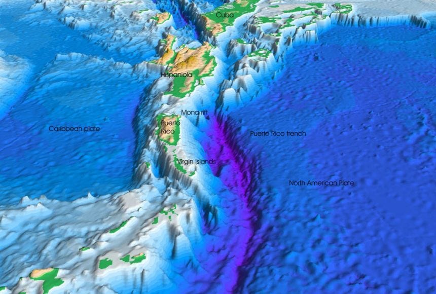
Sea Between St. Thomas & St. Croix Plunges 1.4 Miles
The Anegada Passage, also known as the Bunce Fault by geologists and seismologists, separates Saint Croix from the northern islands.
Just forty-five miles of sea separate the U.S. Virgin Islands and Puerto Rico. Saint John is approximately six miles east of Saint Thomas, and Saint Croix is forty miles to the south of both islands.
Islands Sitting on a Submarine Mount
As sunlight touches the seafloor and reflects against the white sand, the territory’s waters appear crystal clear and turquoise in the shallows. Sailing south of the two smaller islands to Saint Croix, the turquoise water deepens to dark blue. In the depths of blue waters separating Saint Croix from her sister islands is a submarine trench where the water sinks approximately 1.4 miles.
The Anegada Passage, also known as the Bunce Fault by geologists and seismologists, separates Saint Croix from the northern islands. The fault was named after Elizabeth Thompson “Betty” Bunce, a geophysicist whose pioneering research led to ground-breaking discoveries surrounding the Caribbean Plate.
The Anegada Passage has the greatest depth (more than 7,550 feet) of any channel in the eastern Caribbean. If you convert the channel’s depth from feet to miles, it bottoms out around 1.4 miles. For scale, the entrance to the front gate of the Bertha C. Boschulte Middle School to the Bridge-to-Somewhere on Saint Thomas is exactly one mile. And for scale on Saint Croix, if you used the Henry E. Rohlsen Airport’s runway as a ruler, just the tip of the runway would rise above sea level.
The passage boasts one of the most dramatic submarine drop-offs in the region. Geologists believe a massive submarine earthquake occurred in the Anegada Passage in 1867, and within ten minutes, deadly tsunami waves inundated the north coast of Saint Croix and the south shore of Saint Thomas.
The TRITON 7500/3 is one of the few unmanned submersibles capable of diving to 1.4 miles deep and was designed to explore the world's bathypelagic zones.
The Unknown
Saint Croix does sit on the Puerto Rico-Virgin Islands Microplate. The island is still a part of the greater Caribbean Plate but the Anegada Passage forms a mount, separating it from the northern microplate.
There are lots of unknowns about what happens in the depths of the Anegada Passage and the Puerto Rico trench. The Caribbean Sea is home to the only local pod of sperm whales that don’t observe an annual migration. Meaning they stay in the Caribbean all year, hunting squid in the depths. New research continues to unearth their habits and family structure, but scientists still don’t fully understand the local pod’s range or the limits of their feeding grounds.
The Noroit Seamount, located in the Anegada Passage, is an inactive submarine volcano. Because the Caribbean Plate moves eastward, the volcanic arc in the Lesser Antilles forms a subduction zone as it meets the North American Plate.
The Puerto Rico trench, the deepest point of the Atlantic Ocean, is also the site of the most negative gravity anomaly on Earth, -380mGal, a measurement researchers believe indicates the presence of an active downward force. The trench is north of and runs the length of Puerto Rico, Saint Thomas, and the British Virgin Islands and reaches a maximum depth of approximately five miles.
50+ new subs on this post, welcome everyone! 📰🇻🇮
7 is my favorite number and this post generated 27 new subscribers.
hi everyone and welcome to our Substack newsletter! 😁🗞